

GeoAxis Key Insights
What Is GeoAxis?

GeoAxis is an AI powered image geolocation platform that identifies the exact location of any photograph without relying on GPS, EXIF, or embedded metadata. The tool analyses visual cues within an image, including architecture, vegetation, road markings, signage, terrain, and atmospheric conditions, then returns precise coordinates alongside a calibrated confidence band and supporting evidence.
Built for OSINT investigators, journalists, insurance fraud analysts, and law enforcement professionals, GeoAxis runs two core modes from a single upload. Global Search scans worldwide and ranks candidate locations, while HyperVision™ matches street level photos against an indexed database of over five billion reference images for metre level pins. GeoAxis V3, the current release, outperforms every major frontier AI model on the Dataset GSS benchmark, making it the top rated AI image location finder for professional and business use in 2026.
GeoAxis processes only the visual content of an image. It does not need GPS tags, EXIF headers, or any embedded metadata. This makes it ideal for screenshots, social media uploads, and investigative images where metadata has been stripped. The AI reads landmarks, building styles, tree species, and even shadow angles to produce a location estimate.

HyperVision™ is GeoAxis’s proprietary Visual Place Recognition engine. It indexes millions of street level reference images per city and matches uploaded photos against that database. In deployed cities, HyperVision™ achieves accuracy within 10 metres, even at night, in low resolution, or from partial views. This is the feature that separates GeoAxis from every competitor that stops at region level guesses.
Every GeoAxis result ships with a full evidence trail. The platform shows the specific visual cues the AI used, plots evidence pins on the result map, and provides a calibrated confidence score. When the tool cannot resolve a photo, it says so honestly instead of producing a low confidence guess dressed up as an answer. This transparency is critical for investigative and legal workflows.
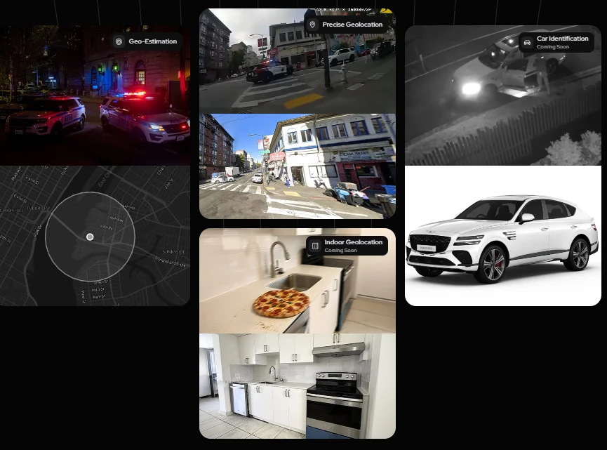
GeoAxis V3 supports batch uploads of up to four images per Global Search run. The AI performs joint reasoning across the batch, improving accuracy significantly when multiple frames of the same scene are available. This saves time for analysts working through large image sets during investigations or insurance claim reviews.
The Effort slider on Global Search gives users direct control over the speed and accuracy tradeoff. Low effort finishes in about 35 seconds with a single pass. Medium runs two parallel passes in about 50 seconds. High runs four passes in roughly 80 seconds for maximum accuracy. This lets analysts choose the right balance for each case.
GeoAxis V3 can call external geospatial tools during its reasoning process. This includes satellite imagery lookups, street view alignment, and signage OCR. Each tool call surfaces as an evidence pin, giving users full visibility into how the AI arrived at its conclusion. This layered approach is what makes GeoAxis results audit ready for professional use.
GeoAxis Pricing Plans
| Plan Name | Cost | Key Features |
|---|---|---|
| Free Demo | $0 | V3 engine access, limited searches, no account required |
| Pro | $29.99/mo | Full V3 backbone, Effort slider, batch upload, PDF exports |
| Business | $79.99/mo | Team access, priority support, advanced reporting |
| HyperVision™ Enterprise | Custom | Custom city deployments, on premise option, API access, indoor geolocation early access |
How GeoAxis Handles Low Quality and Night Images
One of the biggest pain points in image geolocation is poor input quality. Investigators and journalists rarely work with perfectly lit, high resolution photographs.
GeoAxis V3 and HyperVision™ were specifically trained to handle degraded inputs. The platform processes night shots, low resolution screenshots, and photos with minimal visual context. In deployed cities, accuracy stays within 10 metres even under these conditions. This makes GeoAxis a reliable tool for real world fieldwork where image quality is unpredictable and analysts cannot afford false negatives.
Pros and Cons
- Metre level accuracy in cities.
- No metadata or GPS needed.
- Published benchmark beating frontier AI.
- Batch upload for multiple images.
- Full visual evidence trail.
- Free demo with no signup.
- API access is enterprise only.
- Indoor geolocation still coming soon.
- No video geolocation yet.
- Per seat Business pricing not public.
GeoAxis Benchmark Performance Against Frontier AI
GeoAxis V3 was tested on Dataset GSS, a set of 615 street level images from 396 cities across 123 countries. It scored more “correct spot” results than GPT 5.4, Grok 4, Gemini 3.1 Pro, and Claude Opus 4.7 on the standard 0 to 10 image geolocation rubric.
This is the only published head to head benchmark in the AI image geolocation space and it confirms that a purpose built geolocation engine outperforms general purpose multimodal models at this specific task. For teams where accuracy is not optional, this benchmark provides verifiable evidence of GeoAxis’s position at the top of the field.
Best GeoAxis Alternatives
| AI Image Geolocation / OSINT Tool | Accuracy Level | Evidence Trail & Reasoning |
|---|---|---|
| GeoSpy (Raven) | Metre level (gated access) | Proximity clustering and confidence scores |
| Picarta | City level (EXIF assisted) | GPS coordinates with basic confidence scores |
| GeoSeer | Kilometre level (multi agent) | Agent pipeline logs but no visual pin evidence |
| GeoEvident | Indoor and outdoor (forensic focus) | Structured case reports with analyst notes |